Oleron Island
Oleron island is situated in the French administrative division called Charente-Maritime, which is part of the Poitou-Charentes region. It is located to the South of Re island and Aix island.
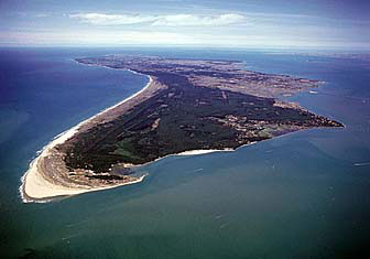
Covering a large area, Oleron is the second largest metropolitan France island after Corsica. It is nearly thirty-five kilometers (22 miles) long and fifteen kilometers (9 miles) wide.
Geography
The territory of the island of Oleron is divided among eight municipalities. By road, twenty eight kilometers (17 miles) separate Chassiron headland, to the North, from the bridge, to the South.
Beaches and marshes
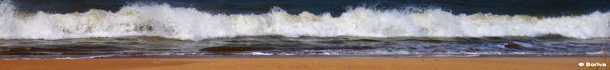
Oleron island is mostly flat, with a culmination at thirty-four meters. Its coastline is lined with beaches, most of them being sandy.
A large area of the island, in the east and the south, is occupied by marshes, which are only partly exploited.
Bicentennial forests
There are three forests in Oleron Island: Saint-Trojan's forest at the South-West, Domino's forest at the North-West, and Saumonards forest at the East.
These forests have been planted two centuries ago to protect the island from the expansion of sand dunes.
Activities
Oleron's mild climate allows to take full advantage of its numerous leisure opportunities during the holidays, from cycle rides to boat trips, or even first flights.
Numerous sports are available, including nautical sports, horse riding, golf and tennis.
Finally, there are a lot of possibilities for tourism and for cultural visits: Chassiron lighthouse, Oleron Island Museum, Saint-Trojan's train…
Hotel and camping
There is a very varied array of accommodation in island of Oleron, whether in traditional hotels, club hotels or camping sites.
A lot of private owners rent out their houses in the summer season, either directly or through estate agencies.
How to get to Oleron island?
By car, Oleron is served by the A10 motorway, fifty kilometres (31.5 miles) away.
By train, from La Rochelle, Rochefort, Saintes and Surgères train stations, bus links are organised.
It is also possible to arrive on island of Oleron by boat.
Bridge of Oleron island
Since 1966, Oleron is linked to the mainland by a three kilometres (1.9 miles) bridge, which is the third longest French bridge after Saint-Nazaire's and Re island's ones.
Originally you had to pay to cross it, but now it is toll-free.
Weather
Enjoying an exceptional sunshine of more than two thousands hours per year, Oleron is nicknamed "La Lumineuse" ("The Luminous").
The island is located in the sunniest area of mainland France in the spring.
Economy
Besides tourism, the main resources of the island are oyster farming, aquaculture, cultivation of vegetables and vines.
Formerly directed largely to the manufacture of Cognac, the harvest can now produce local wines and especially the famous "Pineau des Charentes".
The marshes that occupy much of the east and south of the island were once salt pans providing an important source of income. Some of them are currently used for oyster farming.
The islanders
Nearly twenty-two thousand people live in the island. During the tourist season, the population is eight times higher, and even fifteen times for some municipalities.
Hereafter is the list of Oleron island's eight districts, as well as the main villages joined to them (from North to South).
Useful information: websites appearing on Oleron-Island.net are selected based on the interest of their contents, but product and services they describe have not been tested. Oleron-Island.net is an information resource, and as such has no connection or liability with any of the site mentioned herein.
To the attention of webmasters: if you wish to have your site referenced on Oleron-Island.net or wish to take it out, please contact us. If your site is accepted, its listing is free of charge. Cancellation is also done on request.
Copying text or photos from this site is strictly prohibited.
© Boriva 2009-2024Legal noticeContact us